
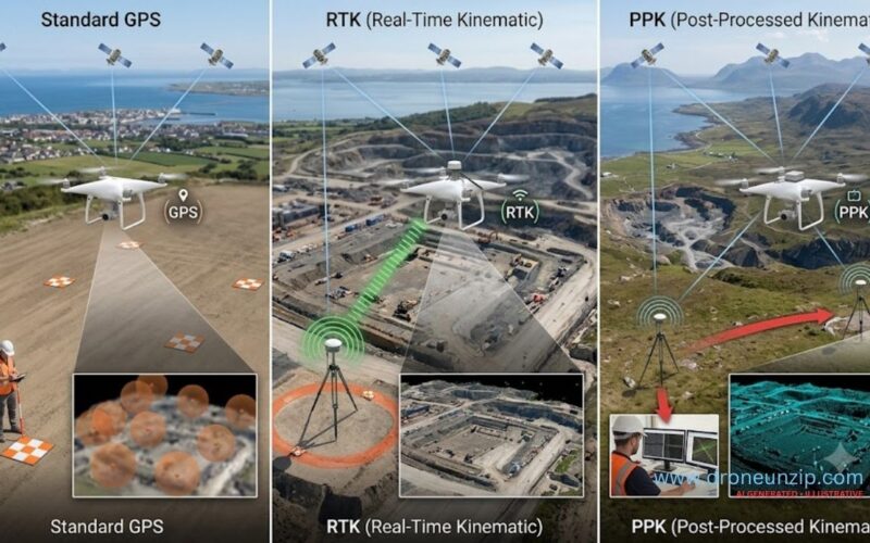
RTK vs PPK vs GPS in drones: all three relate to positioning, but they solve different problems. Standard onboard GNSS provides an approximate location. RTK (real-time kinematic) uses correction information during the survey. PPK (post-processed kinematic) applies corrections after data collection. For mapping professionals, the crucial question is not which acronym sounds more precise, but whether the final orthomosaic, point cloud or elevation model meets a documented accuracy requirement.
For Indian surveyors, construction teams and agricultural mapping operators, this distinction affects field setup, processing time, costs and confidence in deliverables. This is an evidence-based technical explainer, not a field test or a claim that every RTK-equipped drone delivers centimetre-accurate maps.
RTK vs PPK vs GPS: quick comparison
| Method | How it works | When corrections are applied | Practical limitation |
|---|---|---|---|
| Standard GNSS/GPS | Aircraft receives satellite navigation signals to estimate its position | No survey-grade differential correction necessarily applied | Geotags may be too imprecise for demanding survey work |
| RTK | Rover uses observations and corrections from a base station or correction service | During collection | Needs a suitable correction link and reliable positioning solution |
| PPK | Recorded rover and reference observations are processed together | After collection | Requires usable raw observations, reference data and processing |
Terminology note: GPS is one satellite navigation constellation; GNSS is the broader term that can include GPS and other constellations. Consumer marketing often uses “GPS drone” even when a receiver supports multiple GNSS constellations.
What is RTK in a drone?
Real-time kinematic positioning uses measurements from a moving receiver, called the rover, and correction information from a reference station or network. By resolving carrier-phase measurement ambiguities under suitable conditions, RTK can estimate positions far more precisely than an uncorrected standalone GNSS receiver. In drone mapping, the aircraft may use RTK to record more accurate camera positions or flight trajectories.
“RTK enabled” does not guarantee a valid RTK-fixed solution for every photograph. Signal obstruction, multipath, correction outages, distance to a reference, antenna installation and coordinate setup can affect the result. Operators should retain quality indicators and check the final output against independently surveyed checkpoints.
What is PPK in drone mapping?
Post-processed kinematic positioning combines recorded satellite observations from the aircraft with observations from a suitable reference station after the mission. Instead of relying on a continuous real-time correction connection, the operator processes the data later. This can be useful when real-time communication is unreliable, provided the aircraft and reference equipment record the data needed for post-processing.
PPK is not automatically better or worse than RTK. Both can support precise positioning under suitable conditions. The workflow, data completeness, reference coordinates and quality checks determine whether the result is usable.
Why a high-resolution drone image is not automatically an accurate map
A drone can capture extremely detailed photographs while placing them at inaccurate geographic coordinates. Ground sample distance (GSD) describes the ground area represented by a pixel, not the independently verified positional accuracy of the map. The US Geological Survey’s guidelines for calibration of uncrewed aircraft imagery explain that ground control quality, image geometry, tie points and calibration influence geospatial accuracy. A map with a 2 cm GSD is not necessarily accurate to 2 cm.
It also matters which accuracy is being discussed: individual camera geotags, horizontal map position, vertical elevation, relative distances or absolute coordinates in a chosen datum. A single marketing figure cannot substitute for a documented accuracy assessment.
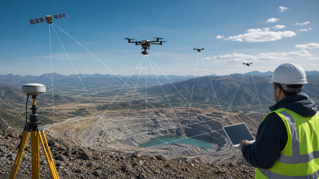
How an RTK or PPK drone mapping workflow works
- Define the deliverable: decide whether the project requires an orthomosaic, digital surface model, terrain model, point cloud or volume estimate, and set horizontal and vertical accuracy tolerances.
- Establish reference coordinates: select a surveyed base station or suitable correction service; verify datum, projection and height reference.
- Plan the flight: choose appropriate altitude, image overlap, cross-flight geometry where useful, safe operating conditions and visible ground targets.
- Capture observations: record images, camera event timing and RTK solution quality, or the raw observations required for PPK.
- Apply corrections: confirm valid RTK positioning or process the PPK observations against reference data.
- Process the imagery: generate the photogrammetric products with appropriate camera calibration and ground control strategy.
- Validate independently: compare the finished products with surveyed checkpoints that were not used to adjust the model.
- Report limitations: state coordinate reference system, check-point errors, processing choices and areas where confidence is lower.
Do RTK and PPK drones still need ground control points?
Sometimes fewer ground control points (GCPs) are needed, but the answer depends on project accuracy requirements, sensor calibration, image geometry and the positioning workflow. Ground control points are known points used to constrain or georeference a model. Checkpoints are independently measured points withheld from model adjustment to evaluate accuracy. Confusing the two can make an accuracy report look stronger than it is.
USGS guidance emphasises the distribution and quality of ground control and recommends independent quality-control measurements. It also warns that a small GSD does not prove equally small geolocation error. See USGS calibration guidance. The appropriate number and distribution of targets should be determined by the survey specification, not a universal “RTK means no GCPs” rule.
Real-world example: a USGS PPK drone survey
A 2026 USGS coastal survey data release describes an aircraft collecting imagery while an RTK base station recorded reference observations. The team applied PPK corrections to the photograph geotags before photogrammetric processing. The release reports an average horizontal accuracy of approximately 0.03 m for corrected photo positions and a horizontal root mean square error of approximately 0.07 m for the resulting orthomosaic, based on independent validation. Those figures describe that particular survey and its methods; they are not universal RTK or PPK performance promises.
The distinction between photo position and final orthomosaic accuracy is the key lesson. A corrected camera trajectory is an important input, but the final mapping product must be assessed separately.
Where RTK and PPK matter in India
Construction and infrastructure
Repeated drone surveys can support earthwork progress records, site orthomosaics and volume estimates. A consistent coordinate reference and repeatable survey methodology are essential when comparing dates. The outputs should not replace legally required ground surveys or engineering checks unless the relevant specification permits it.
Agriculture and land management
Accurately referenced maps can help operators compare field boundaries, crop imagery and intervention areas. Precision requirements vary considerably: a visual crop-health overview may not require the same control strategy as a cadastral or engineering survey.
Mining, quarries and stockpiles
Photogrammetry can help estimate surface changes and stockpile volumes, but shadows, reflective surfaces, weak texture, vegetation and inaccessible check areas can degrade confidence. Survey plans must document these limitations.
Utilities and corridor surveys
Long linear projects create challenges for reference coverage, image geometry and ground control distribution. Correction availability and datum consistency should be checked throughout the corridor.
For a broader introduction to the Indian drone market and applications, see our drone price and use-case guide and drone camera guide.
RTK vs PPK: which should a survey team choose?
| Project condition | What to consider |
|---|---|
| Reliable real-time correction connectivity | RTK can provide immediate solution feedback during collection |
| Intermittent correction link | PPK may preserve a correction workflow if sufficient raw data are recorded |
| Fast field verification needed | RTK status indicators can help, but independent checks remain necessary |
| Strict survey deliverable | Either method requires documented quality assurance, suitable ground control and independent validation |
| Low-cost visual inspection | Standard GNSS may be adequate if precise georeferencing is not required |
Cost comparisons should include the aircraft, compatible receiver, reference service or base station, software, operator time, ground survey work and rework risk. A lower purchase price does not necessarily mean a lower project cost.
Common mistakes in drone mapping accuracy claims
- Confusing resolution with accuracy: a sharp orthomosaic may still be shifted geographically.
- Trusting an RTK badge: verify whether each observation has an appropriate solution and whether the final product meets tolerance.
- Ignoring the vertical datum: GNSS ellipsoidal heights and project elevations are not automatically interchangeable.
- Using GCP residuals as independent proof: report errors at checkpoints excluded from the adjustment.
- Assuming every site behaves alike: vegetation, water, uniform surfaces and poor overlap can create modelling errors.
- Skipping coordinate-system documentation: mixing projections, reference frames or height systems can create major offsets.
FAQs
What is the full form of RTK in drones?
RTK stands for real-time kinematic, a GNSS positioning technique that uses reference observations and corrections during data collection.
What is the full form of PPK?
PPK stands for post-processed kinematic. Corrections are applied after the flight using recorded GNSS observations.
Is PPK more accurate than RTK?
Not inherently. Accuracy depends on the quality of observations, reference information, processing and validation.
Can a GPS drone create survey maps?
It can collect imagery for photogrammetry, but uncorrected camera positions may not meet demanding survey tolerances. Ground control and independent checks may be needed.
Does an RTK drone eliminate ground control points?
Not as a universal rule. Some workflows reduce their use, but project requirements and independent checkpoints still govern accuracy assurance.
What is the difference between GSD and map accuracy?
GSD measures the ground size of an image pixel; map accuracy measures how closely mapped positions agree with reliable reference positions.
Can I use RTK drones anywhere in India?
Precision positioning does not override airspace restrictions or aviation rules. Check current permissions and operational requirements for the flight location. Our India drone registration guide provides regulatory context.
Final takeaway
Choose GPS, RTK or PPK according to the accuracy your project actually needs and the evidence you can produce. RTK applies corrections in real time; PPK applies them later; ordinary GNSS provides useful but potentially less precise positioning. None of them, alone, guarantees an accurate map. Well-designed image capture, trustworthy reference coordinates, appropriate processing and independent checkpoints turn drone imagery into defensible geospatial data.
